Geospatial AR leverages GPS and mapping data to overlay digital content onto real-world locations, enabling experiences anchored to broad outdoor environments. Localized AR, on the other hand, relies on precise spatial recognition and markers within confined spaces for highly accurate and context-specific interactions. Both approaches enhance user engagement by blending virtual elements with physical surroundings, yet differ in scale and technical requirements.
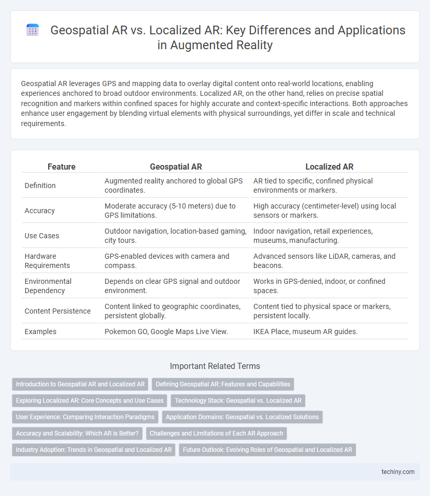
Table of Comparison
| Feature | Geospatial AR | Localized AR |
|---|---|---|
| Definition | Augmented reality anchored to global GPS coordinates. | AR tied to specific, confined physical environments or markers. |
| Accuracy | Moderate accuracy (5-10 meters) due to GPS limitations. | High accuracy (centimeter-level) using local sensors or markers. |
| Use Cases | Outdoor navigation, location-based gaming, city tours. | Indoor navigation, retail experiences, museums, manufacturing. |
| Hardware Requirements | GPS-enabled devices with camera and compass. | Advanced sensors like LiDAR, cameras, and beacons. |
| Environmental Dependency | Depends on clear GPS signal and outdoor environment. | Works in GPS-denied, indoor, or confined spaces. |
| Content Persistence | Content linked to geographic coordinates, persistent globally. | Content tied to physical space or markers, persistent locally. |
| Examples | Pokemon GO, Google Maps Live View. | IKEA Place, museum AR guides. |
Introduction to Geospatial AR and Localized AR
Geospatial AR utilizes GPS, accelerometers, and digital compasses to anchor digital content to specific geographic locations, enabling outdoor navigation and location-based experiences. Localized AR relies on detailed environmental mapping and spatial recognition technologies like SLAM (Simultaneous Localization and Mapping) to overlay virtual objects accurately in smaller, controlled spaces such as indoor environments. These technologies differentiate AR applications by their scale and the precision of spatial interaction, with Geospatial AR suited for broad, real-world environments and Localized AR optimized for detailed, context-aware interactions.
Defining Geospatial AR: Features and Capabilities
Geospatial AR leverages GPS, mapping data, and real-world coordinates to anchor virtual content across large outdoor environments, enabling precise location-based interactions. This technology supports extensive spatial awareness and dynamic updates driven by geographic data, facilitating applications such as navigation, urban exploration, and outdoor gaming. Geospatial AR's robust integration with satellite positioning systems and real-time environmental data distinguishes it from localized AR, which relies primarily on fixed, indoor markers or limited physical surroundings.
Exploring Localized AR: Core Concepts and Use Cases
Localized AR leverages precise spatial mapping to anchor digital content to specific physical environments, enhancing user interaction through real-time environment understanding. Core concepts include simultaneous localization and mapping (SLAM), spatial anchoring, and environmental occlusion, enabling seamless integration of virtual objects within confined indoor spaces. Key use cases encompass interior design visualization, interactive museum exhibits, and industrial maintenance, where context-aware information delivery boosts efficiency and engagement.
Technology Stack: Geospatial vs. Localized AR
Geospatial AR leverages global positioning systems (GPS), geographic information systems (GIS), and cloud-based spatial data to overlay digital content accurately on large-scale outdoor environments. Localized AR relies on advanced sensors, computer vision, simultaneous localization and mapping (SLAM), and edge computing to deliver precise, real-time overlays within confined indoor or specific areas. The technology stack for Geospatial AR emphasizes wide-area spatial accuracy and scalability, while Localized AR prioritizes high-resolution environment mapping and low-latency interaction.
User Experience: Comparing Interaction Paradigms
Geospatial AR anchors digital content to real-world locations using GPS data, providing a broad, location-based user experience ideal for outdoor navigation and exploration. Localized AR, relying on precise spatial mapping and sensors, offers more detailed and stable interactions in confined environments, enhancing object manipulation and immersive storytelling. User experience in Geospatial AR prioritizes contextual awareness over wide areas, while Localized AR emphasizes fine-grained interactivity and spatial accuracy for close-range engagement.
Application Domains: Geospatial vs. Localized Solutions
Geospatial AR leverages global positioning systems and large-scale mapping data to enable applications such as urban planning, navigation, and outdoor gaming that require expansive, real-world environmental context. Localized AR relies on spatial anchors and indoor mapping to provide precise, context-aware experiences for sectors like retail, manufacturing, and healthcare, where accurate indoor positioning is critical. The key distinction lies in geospatial AR's emphasis on broad geographic coverage versus localized AR's focus on confined, high-accuracy environments.
Accuracy and Scalability: Which AR is Better?
Geospatial AR leverages GPS and mapping data to provide broad, location-based experiences with scalable deployment across large outdoor areas but often faces accuracy limitations due to GPS signal variability. Localized AR relies on precise sensors and spatial mapping within confined spaces, offering superior accuracy and detailed interaction but with limited scalability beyond specific environments. Choosing the better AR depends on the application's need for either wide-area coverage with moderate precision or high-accuracy positioning within a controlled setting.
Challenges and Limitations of Each AR Approach
Geospatial AR faces challenges in achieving precise location accuracy and stable alignment due to reliance on GPS signals, which can be obstructed by buildings or environmental factors, causing spatial drift and reduced user immersion. Localized AR, while offering high precision through markers or pre-mapped environments, is limited by the requirement for controlled settings and extensive initial setup, restricting scalability and dynamic content updates. Both approaches struggle with real-time environmental changes, computational demands, and varying hardware capabilities, impacting performance and user experience in complex or large-scale deployments.
Industry Adoption: Trends in Geospatial and Localized AR
Geospatial AR utilizes GPS and mapping data to overlay digital information on large-scale outdoor environments, making it highly adopted in industries like urban planning, agriculture, and logistics for real-time spatial analysis. Localized AR, relying on precise indoor positioning and computer vision, is increasingly used in manufacturing, retail, and healthcare to enhance training, inventory management, and patient care. Industry trends reveal a growing preference for hybrid AR solutions combining geospatial accuracy with localized detail to optimize operational efficiency and immersive user experiences.
Future Outlook: Evolving Roles of Geospatial and Localized AR
Geospatial AR leverages comprehensive GPS and mapping data to enhance large-scale navigation, urban planning, and environmental monitoring, while Localized AR focuses on precise, indoor, or close-proximity applications such as retail, maintenance, and interactive displays. Future developments will see Geospatial AR integrating more real-time data streams and AI analytics to enable dynamic, city-wide augmented environments, whereas Localized AR will advance through improved spatial mapping and sensor fusion, driving personalized and context-aware user experiences. The evolving synergy between these two AR types will foster seamless transitions between macro and micro digital overlays, transforming industries ranging from smart cities to immersive retail and healthcare.
Geospatial AR vs Localized AR Infographic