Simultaneous Localization and Mapping (SLAM) technology enables augmented reality applications to create precise, real-time spatial maps for indoor environments where GPS signals are weak or unavailable. GPS-based AR relies on satellite positioning to overlay digital information on outdoor locations but often lacks the accuracy required for intricate interactive experiences. Integrating SLAM with GPS enhances AR performance by combining global positioning with detailed local mapping, offering seamless navigation and immersive user engagement.
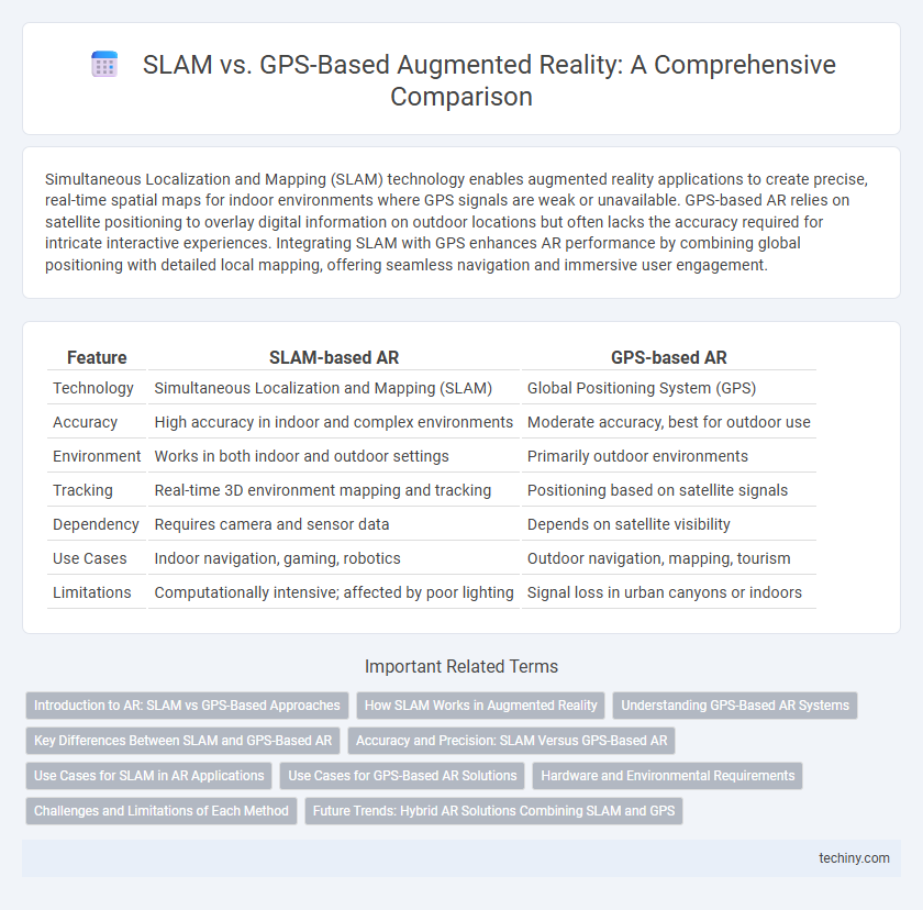
Table of Comparison
| Feature | SLAM-based AR | GPS-based AR |
|---|---|---|
| Technology | Simultaneous Localization and Mapping (SLAM) | Global Positioning System (GPS) |
| Accuracy | High accuracy in indoor and complex environments | Moderate accuracy, best for outdoor use |
| Environment | Works in both indoor and outdoor settings | Primarily outdoor environments |
| Tracking | Real-time 3D environment mapping and tracking | Positioning based on satellite signals |
| Dependency | Requires camera and sensor data | Depends on satellite visibility |
| Use Cases | Indoor navigation, gaming, robotics | Outdoor navigation, mapping, tourism |
| Limitations | Computationally intensive; affected by poor lighting | Signal loss in urban canyons or indoors |
Introduction to AR: SLAM vs GPS-Based Approaches
Simultaneous Localization and Mapping (SLAM) enables augmented reality (AR) devices to build and update maps of unknown environments while tracking their location in real-time, providing precise localization without relying on external signals. GPS-based AR leverages satellite positioning to overlay digital content on geographic locations, offering broad coverage but limited accuracy in indoor or dense urban settings. SLAM excels in environments where GPS signals are weak or unavailable, making it essential for immersive AR experiences in complex, dynamic spaces.
How SLAM Works in Augmented Reality
Simultaneous Localization and Mapping (SLAM) in augmented reality uses real-time data from device sensors and cameras to create a dynamic 3D map of the environment while tracking the user's position within it. Unlike GPS-based AR, which depends on satellite signals and is limited by outdoor settings, SLAM enables precise object placement and interaction indoors by continuously updating spatial information. This technology enhances AR experiences with accurate motion tracking and environmental understanding, making it essential for applications like indoor navigation, gaming, and industrial design.
Understanding GPS-Based AR Systems
GPS-based AR systems rely on satellite signals to determine a user's precise location, enabling the overlay of virtual content aligned with real-world coordinates. Unlike SLAM, which builds a real-time spatial map using cameras and sensors, GPS-based AR provides broader environmental context but lacks fine-grained indoor accuracy and detailed object recognition. This makes GPS-based AR ideal for outdoor navigation applications, location-based experiences, and large-scale geospatial interaction.
Key Differences Between SLAM and GPS-Based AR
SLAM (Simultaneous Localization and Mapping) uses real-time sensor data to create detailed 3D maps and track position indoors or in environments where GPS signals are weak or unavailable. GPS-based AR relies on satellite signals to provide approximate outdoor location data but lacks the precision and environment mapping capabilities necessary for immersive AR experiences. The key differences include SLAM's ability to operate without external signals and provide precise spatial awareness, while GPS-based AR is limited to geolocation and less accurate positioning.
Accuracy and Precision: SLAM Versus GPS-Based AR
Simultaneous Localization and Mapping (SLAM) provides superior accuracy and precision in Augmented Reality (AR) by creating detailed 3D maps of the environment and tracking the user's position in real time, enabling stable and reliable object placement. GPS-based AR relies on satellite signals, which often suffer from signal degradation, multipath errors, and limited spatial resolution, resulting in less precise location data. Consequently, SLAM is preferred for indoor or complex environments where centimeter-level accuracy is critical, while GPS-based AR suits outdoor applications with broader positioning needs.
Use Cases for SLAM in AR Applications
Simultaneous Localization and Mapping (SLAM) technology enhances augmented reality (AR) applications by enabling precise 3D environment mapping and tracking, crucial for indoor navigation, gaming, and real-time object placement where GPS signals are weak or unavailable. Unlike GPS-based AR, SLAM supports complex spatial understanding, making it ideal for use cases like industrial maintenance, medical visualization, and immersive training simulations. The ability of SLAM to create dynamic, accurate digital overlays ensures seamless interaction with physical surroundings in varied indoor and outdoor scenarios.
Use Cases for GPS-Based AR Solutions
GPS-based AR solutions excel in outdoor navigation, location-based gaming, and tourism by providing real-time geospatial context linked to physical locations. These systems enable users to receive information, directions, and interactive content tied to specific coordinates, enhancing experiences in city tours, retail promotions, and public events. GPS-based AR is ideal for applications requiring broad area coverage and straightforward positional data rather than highly detailed environmental mapping.
Hardware and Environmental Requirements
Simultaneous Localization and Mapping (SLAM) requires advanced sensors such as LiDAR, depth cameras, and inertial measurement units (IMUs) to create real-time 3D maps in varying indoor and outdoor environments, enabling precise AR experiences without relying on external signals. GPS-based AR depends on satellite signals and works optimally in open, unobstructed outdoor areas but lacks accuracy in dense urban environments or indoors due to signal degradation. Hardware for GPS-based AR is typically limited to devices with GPS receivers and standard cameras, while SLAM requires more sophisticated, power-intensive components to handle complex environmental data processing.
Challenges and Limitations of Each Method
Simultaneous Localization and Mapping (SLAM) in augmented reality faces challenges such as high computational demand, limited scalability in large or featureless environments, and susceptibility to drift errors over time. GPS-based AR struggles with signal instability, reduced accuracy in urban canyons or indoors, and dependency on satellite availability, which can degrade user experience. Both methods require complementary techniques to overcome environmental constraints and enhance overall AR reliability.
Future Trends: Hybrid AR Solutions Combining SLAM and GPS
Hybrid AR solutions integrating SLAM (Simultaneous Localization and Mapping) and GPS technologies are driving the future of augmented reality by enhancing spatial accuracy and environmental understanding. These systems leverage SLAM's precise indoor mapping capabilities with GPS's wide-area geolocation strengths, enabling seamless AR experiences across both indoor and outdoor environments. Advancements in sensor fusion algorithms and edge computing will further optimize real-time processing, promoting scalable and context-aware AR applications in sectors such as navigation, gaming, and industrial maintenance.
SLAM vs GPS-based AR Infographic