Spatial mapping creates a detailed 3D model of the environment to anchor virtual objects in real-world space, enhancing user interaction through precise depth and surface understanding. Image recognition identifies specific 2D images or patterns, enabling AR applications to trigger content based on visual markers or objects. Both technologies complement each other in augmented reality, with spatial mapping offering immersive environment awareness and image recognition providing targeted information retrieval.
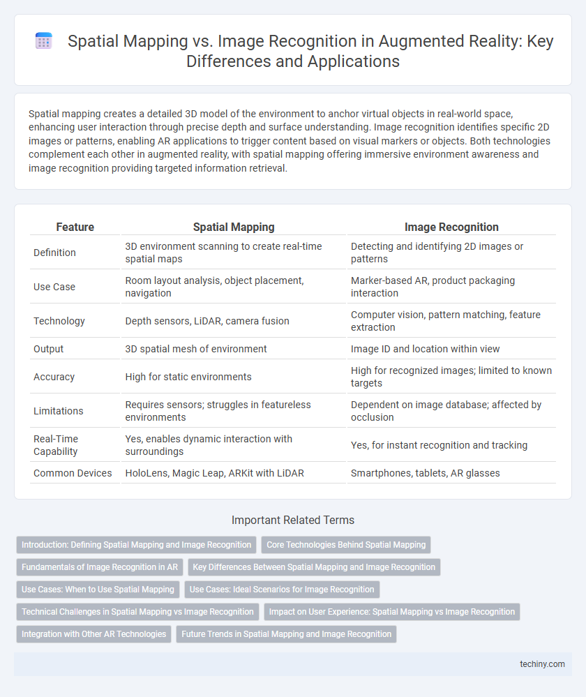
Table of Comparison
| Feature | Spatial Mapping | Image Recognition |
|---|---|---|
| Definition | 3D environment scanning to create real-time spatial maps | Detecting and identifying 2D images or patterns |
| Use Case | Room layout analysis, object placement, navigation | Marker-based AR, product packaging interaction |
| Technology | Depth sensors, LiDAR, camera fusion | Computer vision, pattern matching, feature extraction |
| Output | 3D spatial mesh of environment | Image ID and location within view |
| Accuracy | High for static environments | High for recognized images; limited to known targets |
| Limitations | Requires sensors; struggles in featureless environments | Dependent on image database; affected by occlusion |
| Real-Time Capability | Yes, enables dynamic interaction with surroundings | Yes, for instant recognition and tracking |
| Common Devices | HoloLens, Magic Leap, ARKit with LiDAR | Smartphones, tablets, AR glasses |
Introduction: Defining Spatial Mapping and Image Recognition
Spatial mapping creates a three-dimensional digital representation of an environment by scanning physical space, enabling AR systems to understand and interact with surroundings in real-time. Image recognition identifies and interprets specific visual patterns or objects within captured images to trigger relevant augmented content. Both technologies serve as foundational components in augmented reality, facilitating robust environmental awareness and user interaction.
Core Technologies Behind Spatial Mapping
Spatial mapping relies on advanced depth sensors, simultaneous localization and mapping (SLAM) algorithms, and real-time 3D environment reconstruction to create accurate digital overlays that interact seamlessly with physical spaces. Core technologies include LiDAR, structured light, and time-of-flight cameras that capture precise spatial data for volumetric scanning. These systems enable augmented reality applications to understand spatial relationships and occlusions, enhancing immersion and interaction fidelity far beyond the capabilities of image recognition alone.
Fundamentals of Image Recognition in AR
Image recognition in augmented reality (AR) fundamentally relies on identifying and interpreting visual data from real-world environments using computer vision algorithms, enabling devices to detect and track predefined images or objects. This process involves feature extraction techniques such as scale-invariant feature transform (SIFT) or speeded-up robust features (SURF) to create unique descriptors that facilitate accurate matching in dynamic conditions. Unlike spatial mapping, which reconstructs 3D environments, image recognition focuses on recognizing 2D patterns, making it essential for AR applications like marker-based tracking, interactive advertisements, and object-specific overlays.
Key Differences Between Spatial Mapping and Image Recognition
Spatial mapping creates a 3D representation of an environment by scanning surfaces and objects to enable contextual interactions, whereas image recognition identifies and classifies 2D images or patterns within a scene. Spatial mapping relies on depth sensors and spatial data to map physical spaces, while image recognition uses computer vision algorithms to analyze pixel patterns and colors. The key difference lies in spatial mapping's focus on environmental geometry for immersive AR experiences, opposed to image recognition's emphasis on detecting and interpreting specific visual targets.
Use Cases: When to Use Spatial Mapping
Spatial mapping excels in use cases requiring real-time interaction with dynamic environments, such as indoor navigation, architectural visualization, and industrial maintenance. It enables precise digital overlays on physical objects by creating a detailed 3D map of surroundings, enhancing user immersion and spatial awareness. This technology is ideal for applications needing continuous environmental understanding rather than recognizing predetermined images or markers.
Use Cases: Ideal Scenarios for Image Recognition
Image recognition excels in environments where precise object identification and tracking are crucial, such as retail for product labeling and interactive marketing campaigns. It is ideal for applications requiring the detection of specific visuals or logos, including museum exhibits where detailed information is triggered by artwork recognition. In industrial settings, image recognition enhances quality control by identifying defects or parts, providing real-time insights without relying on spatial context.
Technical Challenges in Spatial Mapping vs Image Recognition
Spatial mapping faces technical challenges such as real-time environmental scanning, ensuring high accuracy in 3D surface reconstruction, and handling dynamic changes in lighting and object movement. Image recognition struggles with variations in image scale, angle, and occlusion, requiring robust algorithms to maintain reliable detection and tracking. Both technologies must optimize computational efficiency for seamless integration in augmented reality applications.
Impact on User Experience: Spatial Mapping vs Image Recognition
Spatial mapping significantly enhances user experience by creating a dynamic, real-world interactive environment that allows precise object placement and environmental understanding in augmented reality. Image recognition, while effective in identifying and augmenting specific images or markers, limits interaction to predefined visual targets and offers less adaptability to changing surroundings. Users benefit from spatial mapping's immersive and seamless integration, whereas image recognition provides rapid, context-specific augmentations but with constrained spatial interaction.
Integration with Other AR Technologies
Spatial mapping in augmented reality constructs detailed 3D models of environments, enabling seamless integration with location-based AR interactions and real-time physics simulations. Image recognition identifies and tracks specific visual markers or objects, facilitating the overlay of contextual digital content linked to recognized images or patterns. Combining spatial mapping with image recognition enhances AR experiences by merging environmental awareness with precise object interaction and contextual augmentation.
Future Trends in Spatial Mapping and Image Recognition
Future trends in spatial mapping emphasize enhanced environmental understanding through real-time 3D reconstruction and advanced sensor fusion, enabling more precise and dynamic AR experiences. Image recognition is evolving with deep learning algorithms that improve object detection accuracy and contextual awareness, supporting seamless integration of virtual content. Combining these technologies will drive the next generation of AR applications, offering immersive interactions and situational adaptability across industries such as healthcare, manufacturing, and retail.
Spatial Mapping vs Image Recognition Infographic