World Anchors provide precise, fixed reference points in Virtual Reality environments, enabling consistent object placement across sessions. Spatial Maps capture a detailed 3D representation of the physical surroundings, allowing dynamic interaction and adaptation to changing environments. Combining World Anchors with Spatial Maps enhances spatial awareness and stability, delivering an immersive and robust VR experience.
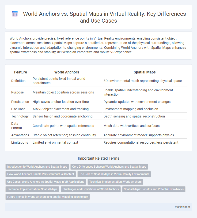
Table of Comparison
| Feature | World Anchors | Spatial Maps |
|---|---|---|
| Definition | Persistent points fixed in real-world coordinates | 3D environmental mesh representing physical space |
| Purpose | Maintain object position across sessions | Enable spatial understanding and environment interaction |
| Persistence | High; saves anchor location over time | Dynamic; updates with environment changes |
| Use Case | AR/VR object placement and tracking | Environment mapping and occlusion |
| Technology | Sensor fusion and coordinate anchoring | Depth sensing and spatial reconstruction |
| Data Format | Coordinate points with spatial references | Mesh data with vertices and surfaces |
| Advantages | Stable object reference; session continuity | Accurate environment model; supports physics |
| Limitations | Limited environmental context | Requires computational resources; less persistent |
Introduction to World Anchors and Spatial Maps
World Anchors are core spatial tracking components in Virtual Reality that lock digital content to real-world positions, ensuring consistent placement across sessions and devices. Spatial Maps create detailed 3D representations of physical environments by scanning and mapping surfaces, enabling immersive and interactive experiences. Together, World Anchors and Spatial Maps enable precise spatial awareness and persistent object positioning in VR applications.
Core Differences Between World Anchors and Spatial Maps
World Anchors are fixed points in physical space that keep virtual content aligned and stable relative to the real world, ensuring persistent positioning across sessions. Spatial Maps capture detailed environmental geometry and surfaces, enabling virtual objects to interact dynamically with the real-world layout. The core difference lies in World Anchors providing precise localization for virtual content stability, while Spatial Maps offer comprehensive spatial understanding for environmental interaction.
How World Anchors Enable Persistent Virtual Content
World Anchors enable persistent virtual content by locking digital objects to precise real-world coordinates, ensuring stability and consistency across sessions. Unlike Spatial Maps that capture and visualize the environment's geometry, World Anchors maintain the fixed position of virtual assets even as the user moves or the environment changes. This persistence is critical for applications such as augmented reality gaming, training simulations, and industrial design, where reliable alignment of virtual and physical spaces is essential.
The Role of Spatial Maps in Virtual Reality Environments
Spatial maps play a crucial role in virtual reality environments by creating detailed, persistent representations of physical spaces that enhance user immersion and interaction accuracy. Unlike world anchors that fix virtual objects to specific real-world coordinates, spatial maps continuously update the environment's geometry and layout, enabling dynamic adaptation to changes in the user's surroundings. This capability supports advanced applications such as real-time occlusion, spatial understanding, and multi-user collaboration within augmented and mixed reality experiences.
Use Cases: World Anchors vs Spatial Maps in VR Applications
World Anchors enable precise, persistent placement of virtual objects in a fixed real-world position, ideal for mixed reality applications requiring consistent spatial alignment like industrial maintenance or architectural visualization. Spatial Maps provide a comprehensive 3D representation of the surrounding environment, supporting dynamic interaction and spatial awareness in gaming, training simulations, and navigation apps. Leveraging World Anchors is optimal for scenarios demanding stable object localization, while Spatial Maps excel in applications needing environmental understanding and real-time spatial interactions.
Technical Implementation: World Anchors
World Anchors in Virtual Reality serve as persistent reference points that maintain the position and orientation of holograms relative to the real world, even across sessions and device reboots. Technically, World Anchors leverage device-specific spatial tracking sensors and environmental understanding algorithms to create a stable coordinate system aligned with the physical environment. By storing anchor data locally or in cloud services, World Anchors enable seamless spatial continuity and enhanced user immersion in mixed reality applications.
Technical Implementation: Spatial Maps
Spatial Maps employ real-time 3D environmental scanning using depth sensors and cameras to construct dynamic, mesh-based representations of the physical space. This technique leverages advanced algorithms for simultaneous localization and mapping (SLAM) to continuously update spatial data, enabling precise object placement and interaction within mixed reality applications. Integration with cloud services facilitates multi-user environments by synchronizing spatial data across devices for consistent virtual content alignment.
Challenges and Limitations of World Anchors
World Anchors face challenges in maintaining precise device localization across changing environments, often requiring recalibration to prevent drift or loss of anchor points in mixed reality scenarios. Unlike Spatial Maps, which offer dynamic, detailed environmental reconstructions, World Anchors rely on fixed coordinate systems that can be disrupted by significant spatial changes or occlusions. Limitations include restricted scalability and issues with persistent tracking in large, complex spaces, impacting seamless virtual-to-physical alignment in extended VR applications.
Spatial Maps: Benefits and Potential Drawbacks
Spatial Maps in Virtual Reality provide highly detailed 3D representations of the physical environment, enabling accurate object placement and enhanced user immersion. They offer dynamic updates and environmental understanding, which facilitate realistic interactions and adaptability in mixed reality applications. However, Spatial Maps can demand significant processing power and storage, potentially causing latency issues and limiting performance on lower-end devices.
Future Trends in World Anchors and Spatial Mapping Technology
Future trends in world anchors and spatial mapping technology highlight increased integration with AI-driven environmental understanding, enabling more dynamic and persistent virtual overlays in augmented reality applications. Advancements in sensor fusion and cloud-based spatial data processing will improve the accuracy and scalability of world anchors, facilitating seamless real-time collaboration across devices. Continued development in machine learning algorithms will enhance spatial map optimization, supporting adaptive environments that respond intelligently to users' interactions and spatial changes.
World Anchors vs Spatial Maps Infographic